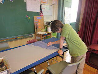
In social studies we have moved onto a super awesome unit studying Maine Native American Tribes. We kicked off the unit by creating three different maps of Maine that can be laid over each other to represent different periods of history in Maine.

The first map the boys created was of Maine pre-European settlement. They showed roughly where Native American tribes were settled before the Europeans came and also labeled archeological sites where Native American artifacts have actually been found in Maine. They also labeled major geographical features such as mountains and rivers, which help them understand why most Native American settled where they did.

Quinn worked on the first map, painting the water so it would show up on all of the other overlays.

He painted the land around Maine green.

Then he painted the different areas where Native American settled different colors. We talked a lot about how these different areas were not actually tribal territories or Native American "states" but just general areas where many of the same tribes lived.

We had to do a lot of fact checking to make sure our maps were just right. We also got to use the Inter-Island school's Social Studies wiki to share resources with the other islands schools that are doing this exact project! How cool is that!?

Then the boys moved onto the second map, which was to show where Europeans settled when they first starting arriving between the late 1500s and the early 1800s. Dalton worked mostly on this map finding researching from our fantastic Maine text book and other online resources. He really had to be quite the detective to try and figure out where some of these settlements were, since many of the names they used when Europeans first came to Maine are not the names we use today!

Lastly it was time to make the last map which was to show where the current Native American reservations are in Maine today. Did you know there are only five?

Now we have the finished product: Map 1: Native American settlements in Maine prior to European settlement

Map Two (on top on Map One): Maine during European Settlement

And Map Three (Over Map One and Two): Present Day Maine with Native American Reservation

Most of the Native American Reservations are now in Central and Northern Maine. And as Quinn pointed out, "they are now much farther away from the settlements they had before the Europeans showed up." This was a very enlightening project for all of us.
i just got my hand stenciled bags from monhegan school.... they are totally wonderful..... its a great way to support the school, help japan and advertise my favorite island...... i love them
ReplyDeletejennifer lea dulin